
East Boston’s Oldest Buildings and Where to Find Them
Written and researched by Dan Bailey.
All photos by Dan Bailey and Matthew Dickey.
In his recent, award-winning book, “Boston’s Oldest Buildings and Where to Find Them,” City of Boston archaeologist Joe Bagley identifies the 50 oldest buildings in Boston, all built before 1800. The book features some well-known historical buildings downtown, but also includes lots of hidden and unexpected buildings in neighborhoods across the city. But none of the buildings in my neighborhood, East Boston, made the cut – which got me thinking, where are the oldest buildings in East Boston, and how old are they?
East Boston began to be developed as a neighborhood in 1833 when a group of wealthy investors bought Noddle’s Island in Boston Harbor, renamed it East Boston, and began selling lots on the island. These investors organized a real estate venture called the East Boston Company in order to manage land sales and create a plan for the new neighborhood.
In 1837, four years into this neighborhood building enterprise, the East Boston Company published a map of the neighborhood showing “all buildings and other improvements.” Around 100 buildings appear on the map, including a few warehouses and industrial buildings along the western waterfront and a scattering of houses arranged in two clusters, one around present-day Maverick Square, and one on the western slope of Eagle Hill.
I began my search for East Boston’s oldest buildings with this map – how many of the mapped buildings, built between 1833 and 1837, are still standing today? To answer this question, I looked through deed records, aligned building footprints on later historical maps, and visited each candidate building. In the end, I found that about a dozen of the buildings shown on the 1837 map still exist today. (There may be a few more, but they have been so thoroughly altered that it’s difficult to confirm whether the original structure from the 1830s is still present today.)
Some of these buildings are buried beneath layers of alterations while others look more or less as they did when they were built 185 years ago. All of the surviving buildings from this time were built for residential use, although some have now been adapted for other uses. Some are large, spacious homes built for wealthy individuals, but most are modest worker houses. None of the buildings on this list have Landmark status and many are vulnerable to demolition, either through neglect or redevelopment. In fact, as I write this, one of the houses on the list, the Morgan-Morrill House at 44 Cottage Street (1836), is slated for demolition and may be lost any day now. (Spoiler Alert: It has since been demolished)
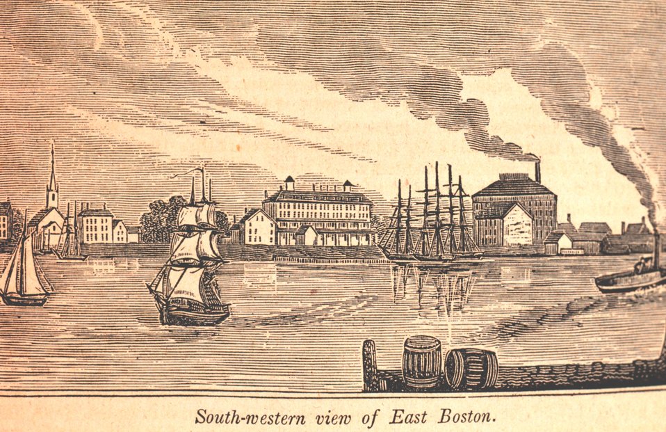
Each of these buildings provides a material link to East Boston’s origins and tells us something about how the neighborhood came to be what it is today. When these houses were built in the mid-1830s, East Boston more closely resembled the sleepy harbor island it had been for the previous 200 years than the busy, urban neighborhood it would become. Beyond a handful of unpaved, freshly graded streets and a scattering of buildings along the western waterfront, the neighborhood ended abruptly, with rolling meadows, salt marshes, and mud flats stretching out to the north and east. Crews of laborers, many of them recent Irish immigrants, were constructing granite wharves and sea walls, leveling building lots, and filling in tidal marshes across East Boston. So little housing existed on the island that many of these laborers lived in improvised houses (described as “shanties” at the time) at the periphery of the new neighborhood. Members of the Penobscot Tribe spent summers on the island through the 1830s, a continuation of seasonal use of the harbor islands by indigenous people that stretched back thousands of years. Neither the seasonal Penobscot dwellings nor laborers’ improvised houses appear on the 1837 East Boston map. Of course, none of these structures remain today, and most of the buildings on the 1837 map are gone as well. But the surviving buildings from this period connect us to the small but diverse group of people who made homes in East Boston in the neighborhood’s earliest days.
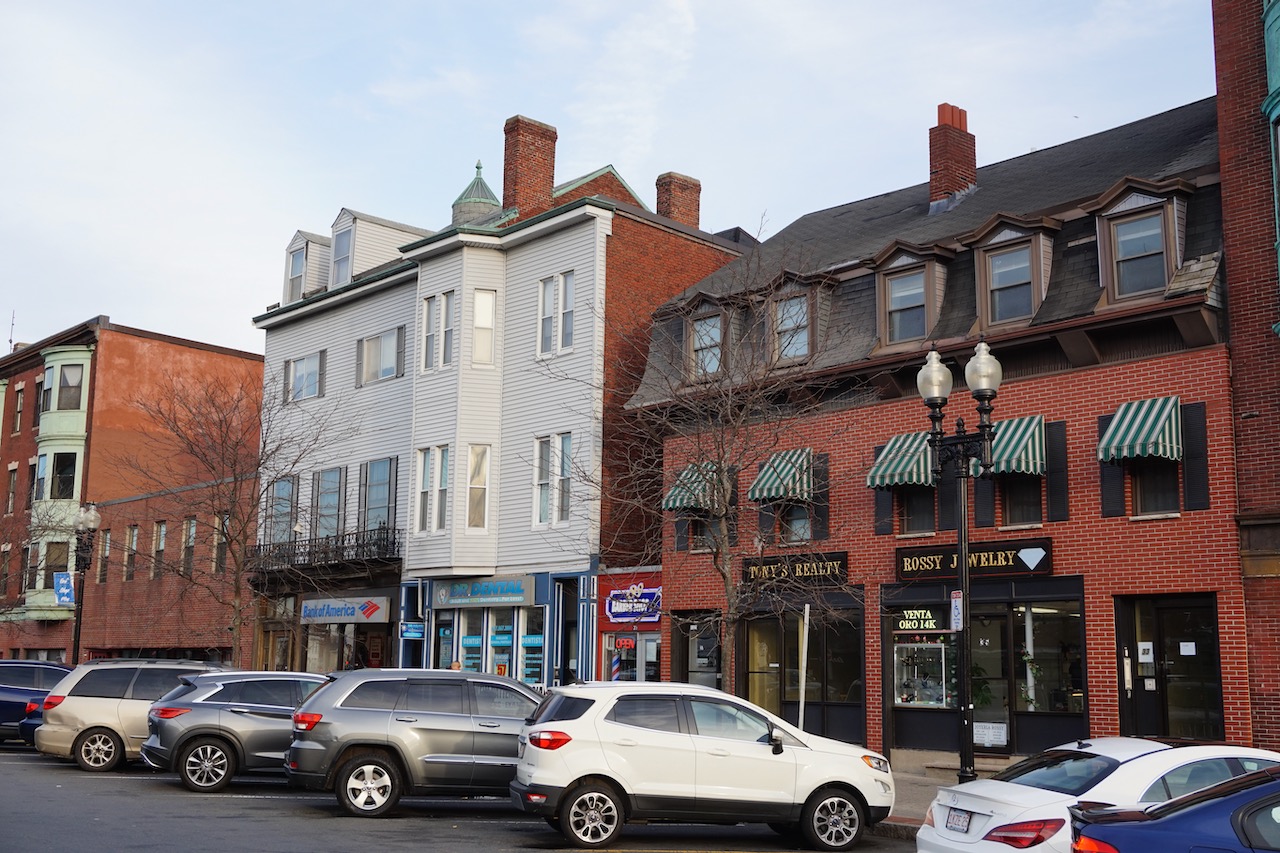
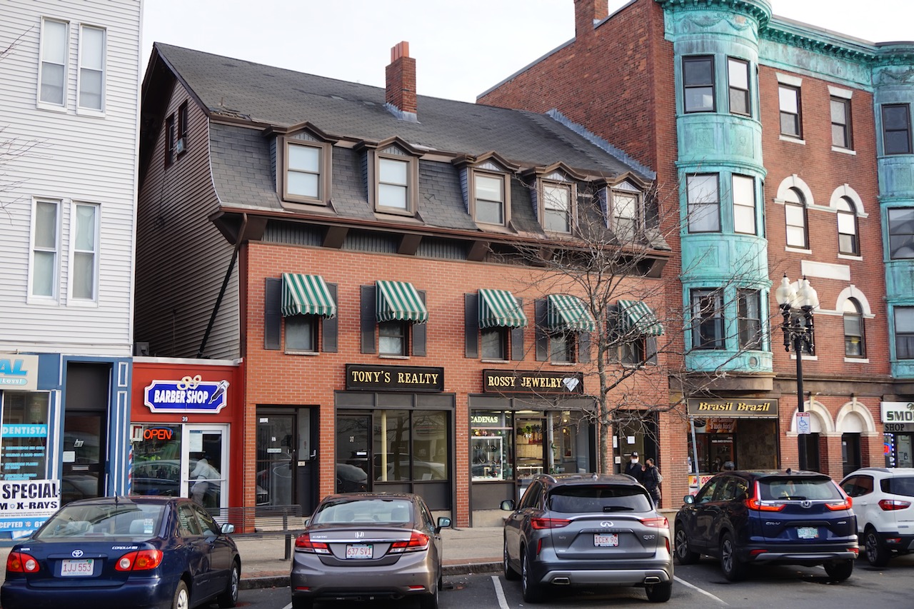
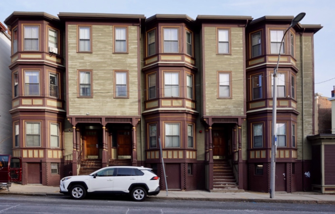
Fettyplace-Thorndike House, 47 Maverick Square, 1835-1837
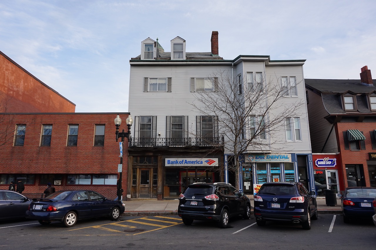
William Fettyplace House 2021. The left third of the house and an 1890s addition were replaced by the low, brick building on the left in the mid-20th century. Photo by Dan Bailey.
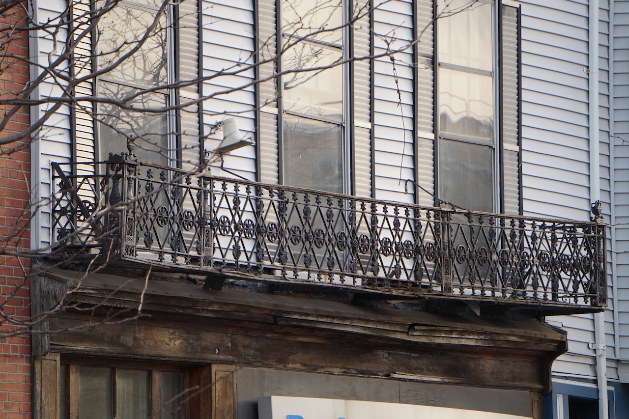
A decorative cast iron balconette and nine-over-nine floor-length windows (just visible behind storm windows) on the second floor appear to be surviving original features.
https://cityofboston.access.preservica.com/uncategorized/IO_1eeca608-9fdf-4bb4-9b14-540392e17564/
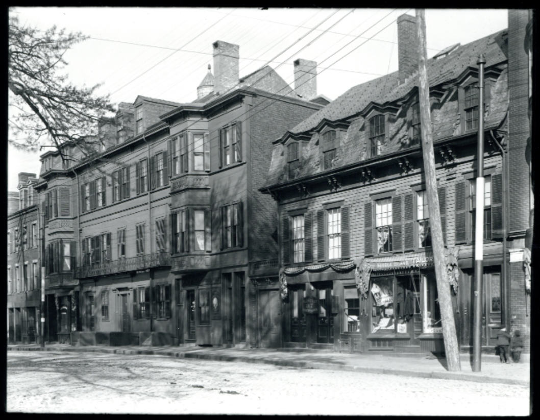
The Pollard and Fettyplace Houses shown circa 1900 (above) and in 2021 (below).
The Fettyplace-Thorndike House is the last of the grand suburban homes built in East Boston in the 1830s still standing today. It was built between 1835 and 1837 for William Fettyplace as his personal home. Fettyplace, a sea captain and merchant from Salem, was one of the earliest investors in the East Boston Company and served on the Company’s board in the late 1830s.
During this period, a number of East Boston Company investors built personal estates in the more secluded corners of the island, especially in the far reaches of present-day Jeffries Point. But when Fettyplace moved to East Boston in 1835, he chose to build his house in Hotel Square (present-day Maverick Square), at the center of the new neighborhood.
The house was originally built as an asymmetrical, side-by-side double house, with the main house making up two thirds of the building’s footprint and a smaller, attached house making up the remaining third. Like most double houses of the period, the two houses shared a central partition wall but had the outward appearance of a single, large house with a continuous, unified facade. Although the house’s side walls are brick, the facade was built from wood disguised to look like stone with a number of Federal design elements. At three and a half stories tall, Fettyplace’s house was one of the largest buildings in the Square when it was built.
After William Fettyplace’s death in 1867, brothers George and William Thorndike purchased the house. Between 1882 and 1892, George Thorndike, a real estate agent, built adjoining buildings in the yards on either side of the Fettyplace House. These buildings were constructed with materials and design elements that matched the original house such that the expanded building continued to read as a single, broad facade, with two symmetrical additions at either end. In the 1880s and 90s, George Thorndike’s real estate offices were located in one of these additions and he and his business partner, Eugene Kaler, each lived in half of the original double house. Perhaps George Thorndike’s most lasting contribution was his endowment of the Thorndike Memorial Laboratory at Boston City Hospital (now BMC) in memory of his brother William, a surgeon. The Thorndike Laboratory was the first clinical research lab at a municipal hospital in the country and operated from the 1920s through the 1970s as part of Harvard Medical School.
Sometime in the mid-20th century, the smaller, left-most third of the Fettyplace House was demolished along with the Thorndike addition that was attached to it. Today, the main two thirds of the Fettyplace House and one of Thorndike’s 1890s additions still stand. Although the house now exists in a somewhat diminished form, you can still make out elements of the original, stately building. The second floor facade is mostly intact with floor-to-ceiling windows behind an elaborate, cast-iron balconette. The pitched roof and pedimented dormers are also unchanged. And near the very top of the roof, just visible from the street, is an apparently original, magnificent conical skylight that presumably illuminates the interior stairwell.
Joshua Pollard House, 33-39 Maverick Square, 1835
Joshua Pollard House, 2021.
The Pollard House, located next to the Fettyplace House in Maverick Square, was built in 1835 for Joshua Pollard. It isn’t clear whether Pollard, a grocer and merchant, ever lived in the house – his primary address is listed in downtown Boston in the 1836 city directory. At the time, the East Boston Company was marketing the neighborhood as a convenient rural retreat for wealthy Bostonians, noting in an 1836 report that “the most delightful situations are to be found for villas and rural residences.” A number of well-to-do individuals actually built “rural residences” and summer homes on the island in the 1830s. Pollard may have been one of them, using his East Boston home as an island getaway.
The house itself is quite large, 2.5 stories tall, with its long side facing the Square. Its gambrel roof makes it an oddity in East Boston where gable-roofed buildings were constructed almost exclusively through the 1860s. The Pollard House has changed little over the past 185 years. Originally built for residential use, the ground floor was converted to retail space as Maverick Square became a business district. Cornice brackets and other Italianate decorations were added to the facade at some point in the late 19th century, and more recently, the wood-frame, clapboard facade was bricked over.
Morgan-Morrill Double House, 42-44 Cottage Street, 1836
Morgan-Morrill Double House, 2021 (demolished).
In 1836, housewrights Enos Morgan and Elijah Morrill built a double house near the corner of Cottage and Sumner Streets in present-day Jeffries Point. It was nearly identical to other double houses built in the neighborhood in the 1830s and 40s: two-and-a-half stories tall with a pitched roof, and a side-by-side layout, two rooms deep, with paired front doors at the center. Like many other double houses in the neighborhood, it was later expanded – a full third story and flat roof was added to the left half of the house in the late 19th or early 20th century.
After standing for 186 years and housing generations of East Boston families, the right half of the Morgan-Morrill Double House is now slated for demolition and redevelopment. The entire house, from the roof rafters to the brick and fieldstone foundation and everything in between, will likely end up in a landfill, something that would have been unthinkable when the house was built. In the 1830s, buildings that had reached the end of their useful lives were typically disassembled and the building materials were reused. Just three years before Morgan and Morrill built their double house, the East Boston Company removed the abandoned barracks from the ruins of an earthworks fort built during the War of 1812 in present-day Brophy Park at the top of the hill in Jeffries Point. Rather than disposing of the barracks, the Company moved the structure to Eagle Hill and converted it into a house.
Porter Norris Row, 172-176 Sumner Street & 6-10 Paris Street, 1835
Porter Norris Row, 2022. Image by Matthew Dickey.
http://www.publicdomainfiles.com/show_file.php?id=13953604814166
View of East Boston from Downtown, 1841. The large building at the center is the Maverick House Hotel. The gabled building just to the left is the side of the Porter Norris row. The Porter Norris Row is the only building depicted here still standing today.
In 1835, housewright Porter Norris built a row of four attached houses at the corner of Paris and Sumner Streets, just outside Maverick Square. The houses were simple – three and a half story wood-frame structures with gable roofs and clapboard facades with little or no decorative features. Today they look more or less the same as when they were built.
The houses’ surroundings, on the other hand, have changed dramatically. Standing in front of the Norris Row today, the view in all directions is blocked by dense walls of buildings. When the Row was built, it faced a large open space in front of the Maverick House, an 80-room luxury hotel built by the East Boston Company to attract vacationers to the new neighborhood. William Sumner, the first president of the East Boston Company described the open space in front of the hotel as “a kind of exchange for the Island. The shade of the great willow tree in the centre, under which seats were conveniently arranged, invited knots of persons, who discussed land speculation or politics, as the occasion dictated.” Just across Sumner Street was a beach, sometimes used by guests of the Maverick House for “sea bathing”, and beyond the beach was the harbor and an expansive view of downtown.
Today, the Maverick House is long gone, and wharf construction over the course of the 19th century covered the beach and moved the waterfront 150 yards southwest. To enjoy the harbor view today, you’d need to leave the Norris Row, cross Sumner Street, and make your way through the new Clippership Wharf development to reach the water’s edge.
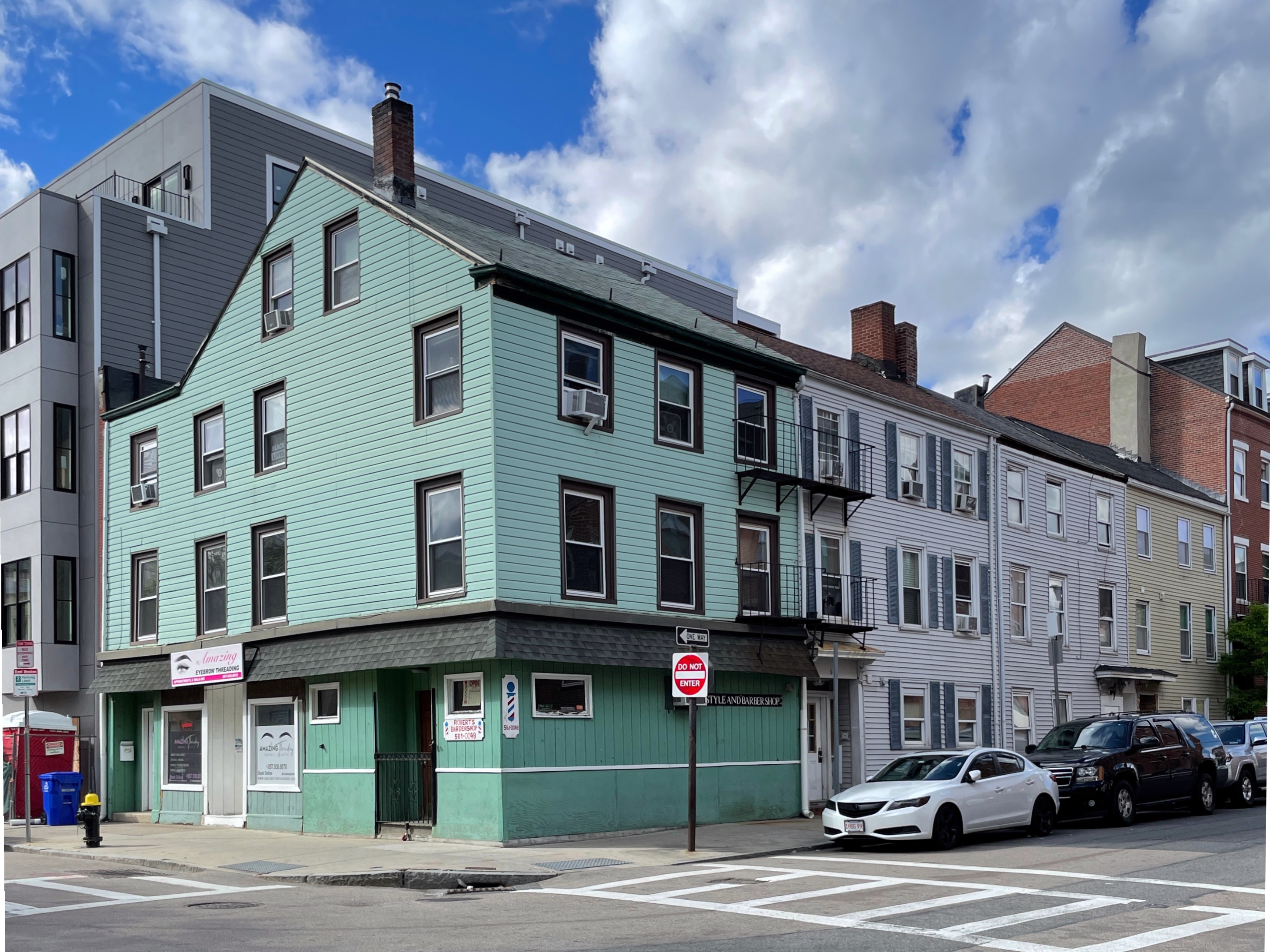
Cummiskey-McManus Double House, 58-60 Maverick Street, 1836
Cummiskey-McManus Double House, 2022. Photo by Matthew Dickey.
In 1836, Hugh Cummiskey and Patrick McManus bought a small lot of land at the corner of Maverick and London Streets from Stephen White, a merchant, and East Boston Company board member. Later that same year, they built a small double house on the lot. The two side-by-side, attached houses were modest – a two-and-a-half-story tall, wood-frame structure under a pitched roof. It was a type of house that had changed little in the previous hundred years, and it was one of the most common house types built in East Boston through the 1860s. While there have been fairly minor changes to the left half of the Cummiskey-McManus House in the past 185 years, the right half was converted to a triple decker with ground floor retail space sometime between 1892 and 1901. The alignment of floor heights between the two halves of the building suggest that the structure of the original 1830s house is likely buried within the current triple-decker.
Like later triple-deckers, double houses were a ubiquitous urban house type because they provided an economical way to build comfortable, multi-family housing within the constraints of a dense, walkable city. Unlike triple-deckers, double houses lacked a class dimension – large, ornate examples like the Fettyplace House were constructed for wealthy individuals while small, plain double houses were constructed for working families.
The Cummiskey-McManus House falls into the latter category. McManus worked as a laborer and Cummiskey was a lighterman, or barge operator. Both were Irish immigrants and both were among the earliest investors in the East Boston Company, purchasing a small number of shares when the Company was incorporated in 1833. Beginning that year, McManus and Cummiskey entered into business together, receiving contracts from the East Boston Company to lay out streets, level building lots, and construct wharves. Between 1833 and 1837, they oversaw a massive landfill project, resulting in the construction of an 8-acre granite ferry wharf and a street connecting the wharf to Maverick Square (present-day Lewis Mall and Lewis Street).
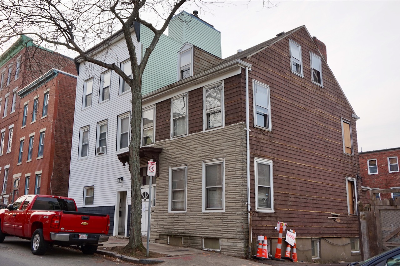
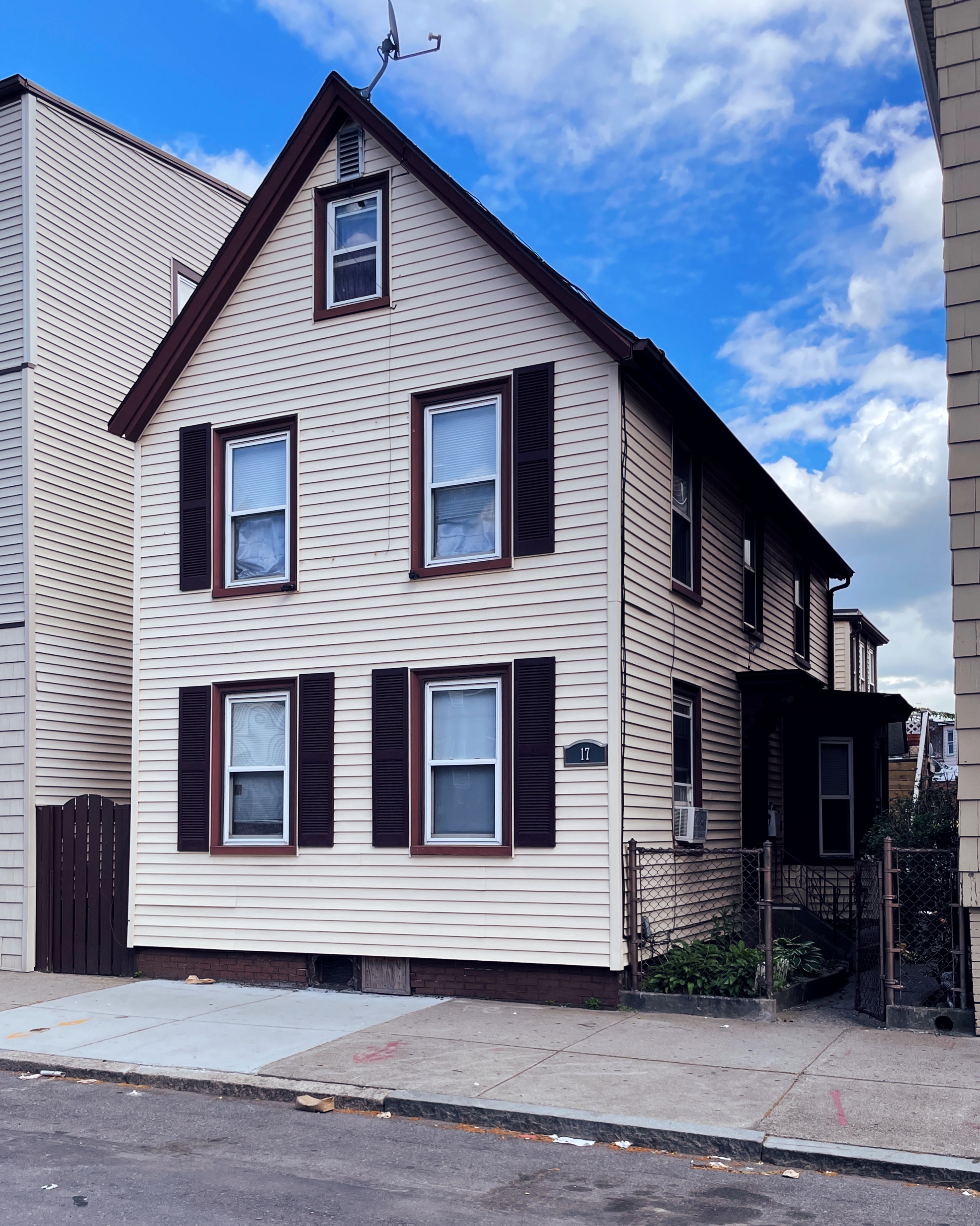
Daniel Crowley House, 90/92 Maverick Street, 1834
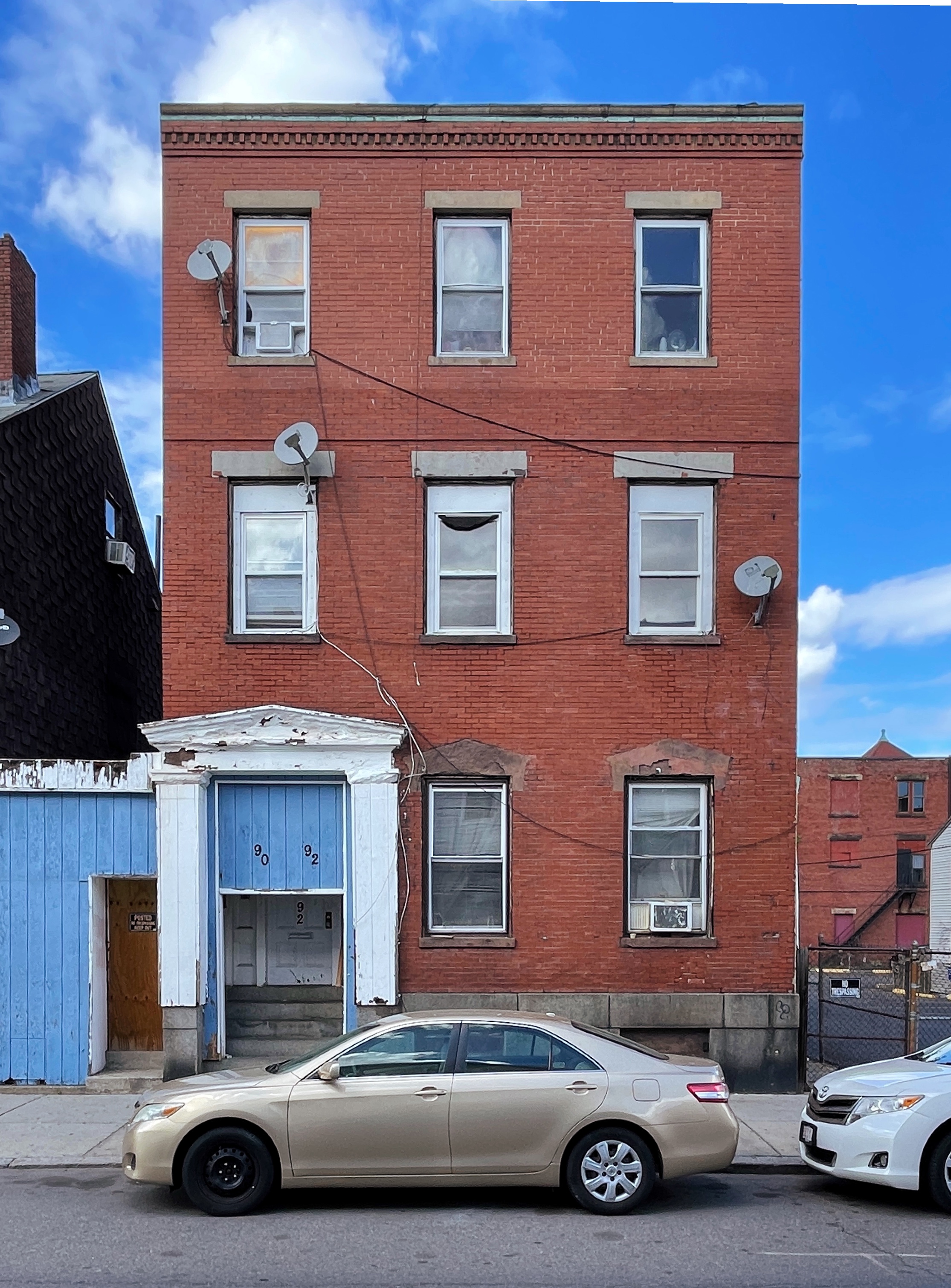
Daniel Crowley was an Irish immigrant who described himself as a laborer and contractor in city directories. Like McManus and Cummiskey, he was awarded contracts from the East Boston Company to transform the island landscape, filling marshes, grading streets, and terracing building lots into hillsides. Crowley purchased a small lot on Maverick Street behind Maverick Square in 1834 and constructed a house that same year. It was the third private dwelling built in East Boston and is now the oldest remaining building in the neighborhood.
While most houses in 1830s East Boston were wood-frame structures, Crowley built his house from brick over a granite basement and invested in elaborate Greek Revival ornamentation – carved brownstone pilasters, entablature, and pediment around the front door and pedimented brownstone hoods over the first floor windows. Originally topped with a gable roof, the house’s attic was squared off later in the 19th century to create a full third story.
Crowley was given the nickname “King Crowley”, a name that seems to have been intended to poke fun at the apparent incongruity of an Irish immigrant laborer living in such a fashionable home. Even so, Crowley lived up to the name. In subsequent decades he continued to acquire property and build wealth in East Boston. He became a leader in the neighborhood’s growing Irish community and was largely responsible for establishing East Boston’s first Catholic Church in 1844. Crowley was one of the first immigrants to build a successful life in East Boston, but as successive immigrant communities continued to settle in the neighborhood, his story would be repeated many times over.
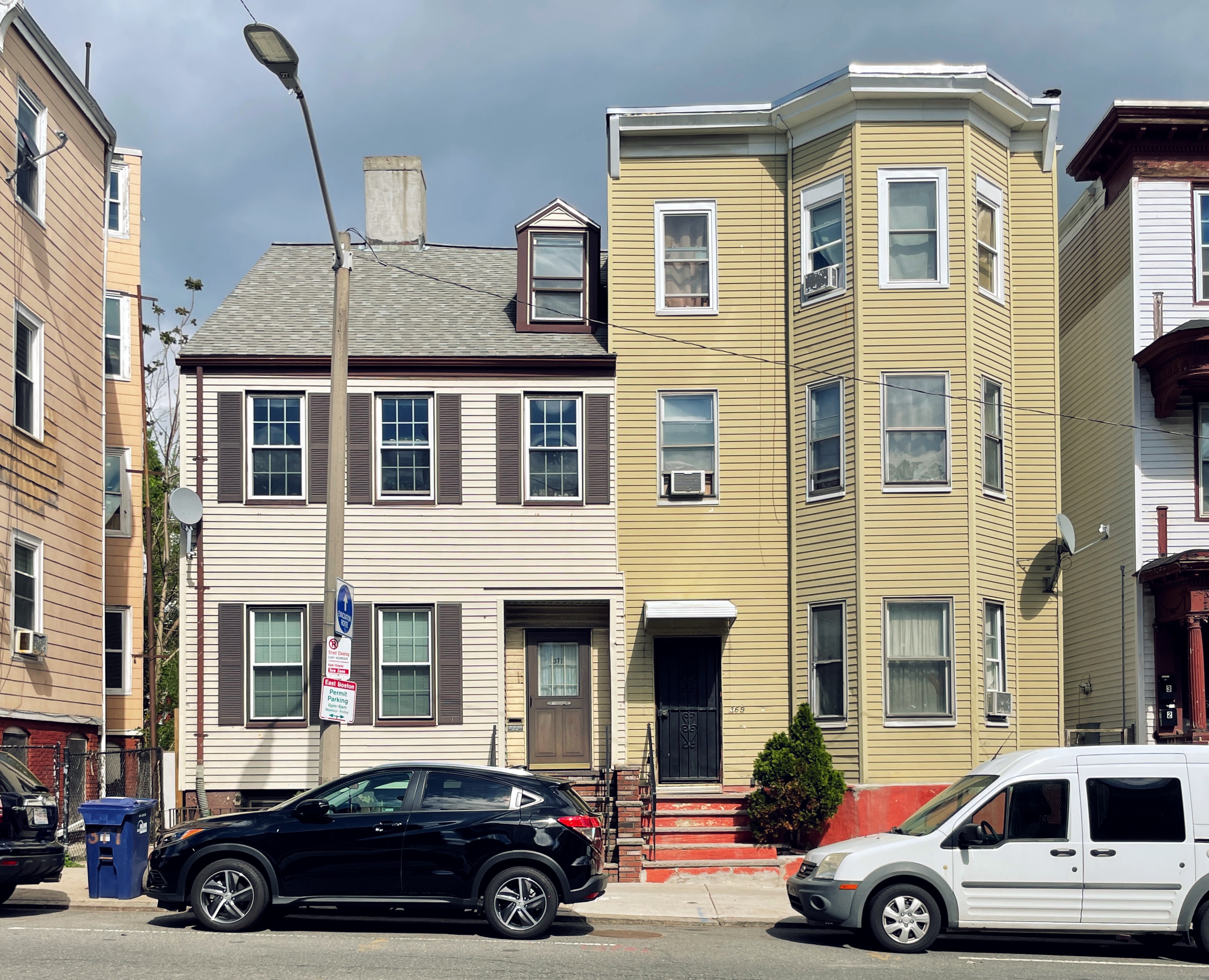
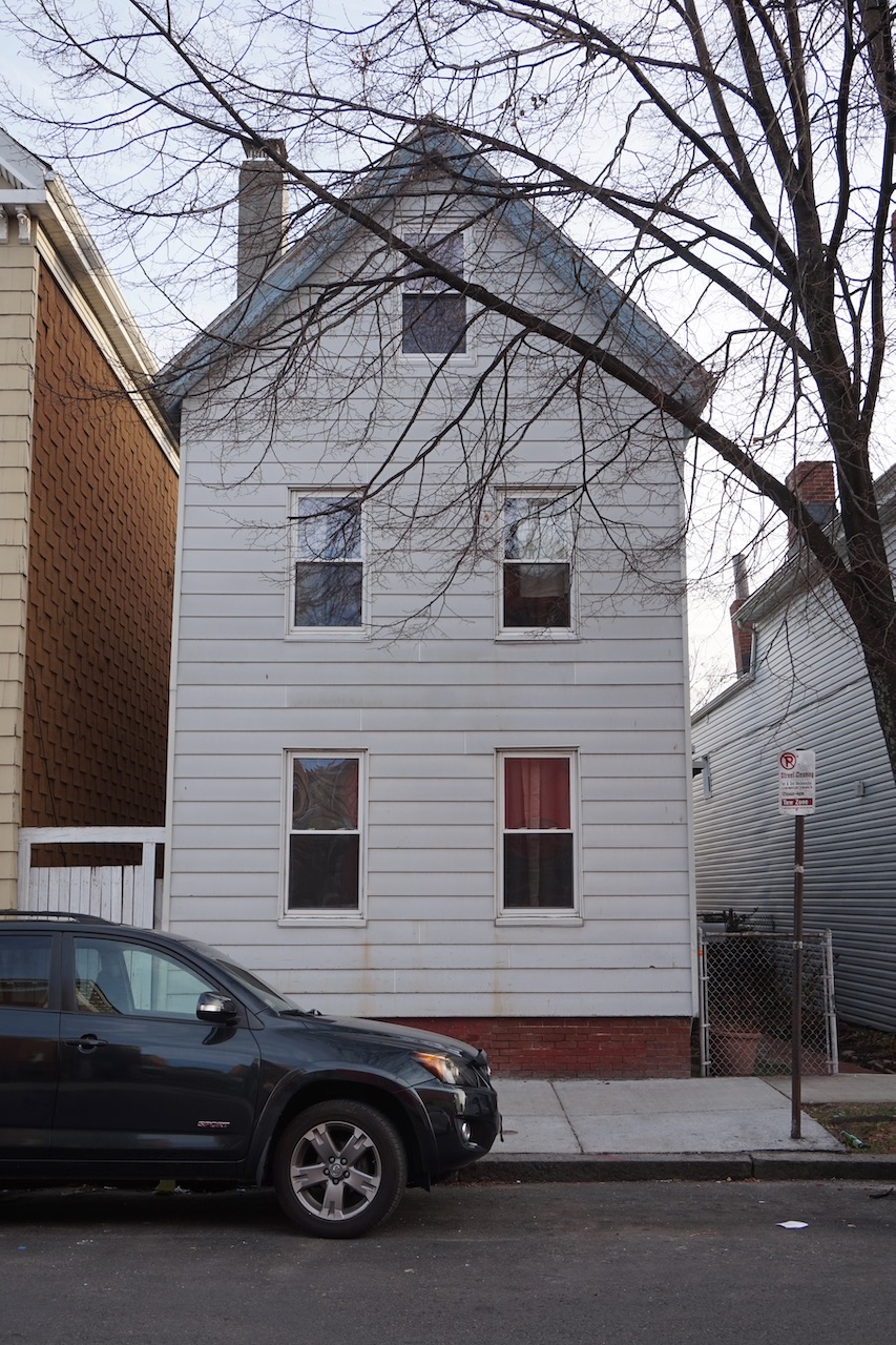
John Duncan Double House, 46-48 Paris Street, 1837
John Duncan, a tailor, built a small double house, just one room deep, on Paris Street behind Maverick Square in 1837. City Directories indicate that Duncan lived in the house for many years.
Much of the building construction and land sales in 1830s East Boston were fueled by speculative investments from some of New England’s wealthiest merchant families. Names like Parkman, Shaw, and Delano show up over and over again in deed records from this period. But compared to mainland Boston, land values in the new neighborhood were relatively low, providing an opportunity for some working people like Duncan to purchase property and build homes.
When the Duncan House was built, it was at the very edge of the ‘upland’ around Maverick Square. Just to the north of Duncan’s property the land dropped off into a vast salt marsh known as “The Great Marsh”. This long stretch of intertidal lowland divided the island in half, separating Maverick Square from Eagle Hill. Long ago erased by land-filling projects, the Great Marsh can be seen reemerging in maps of future flood risk projections.
In the 1830s, Duncan would have enjoyed an unobstructed view across the Great Marsh to the grassy slopes of Eagle Hill. Meridian Street, completed just a few years earlier by the East Boston Company at great expense, ran across the marsh on a raised causeway. An odd, steel track raised above the marsh on timber posts ran parallel to Meridian Street. This suspension track was all that remained of an experimental monorail designed and constructed by Henry Sargent in collaboration with the East Boston Company in 1834. The monorail, or suspension railway as it was known at the time, was an eccentric scheme to attract visitors to the nearly uninhabited island, but it was ultimately a failure – it ran for just nine days before closing due to a lack of riders.
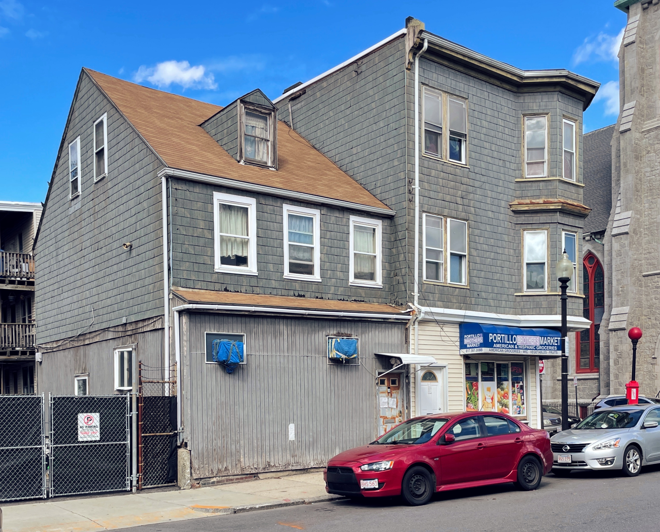
Boyden Malleable Iron Works Housing, 369-371 Meridian Street, 357-363 Meridian Street, 20-22 Eutaw Street, 30-34 Eutaw Street, and 40-42 Eutaw Street, 1835
Boyden Malleable Iron Works Housing, 2021. The altered boarding house is on the left. House 1 is on the right. The one-story corner store in the foreground was an early 20th century addition.
Alexander Boyden established an iron foundry on Meridian Street along the western slope of Eagle Hill in 1835. In the 1820s, Alexander’s brother, Seth Boyden, invented a process for making malleable cast iron – an improvement over earlier cast iron which tended to be brittle – and operated a successful iron foundry in Newark, New Jersey. Alexander brought his brother’s technology to East Boston.
Boyden’s foundry was one of the largest industrial operations on the island at the time. It was the first building constructed on Eagle Hill, and because it was separated from Maverick Square and the ferry landing by a large salt marsh, the East Boston Company agreed to build a new street called Meridian Street to cross the marsh and connect the foundry to the rest of the neighborhood.
At peak production, Boyden’s Iron Works employed about 300 workers, and since it was located in a remote and undeveloped corner of East Boston, the Iron Works constructed housing for its workforce. This company housing was clustered on the first block of Eutaw Street just off Meridian Street, kitty corner to the foundry. Boyden’s Iron Works operated for just four years, shutting down in 1839 when “it was found to be an unprofitable concern.” The foundry building was sold off and repurposed for other industrial uses, including a soap and candle factory and a linseed oil refinery, before it was demolished in the late 19th century to make way for housing. Although the foundry itself is long gone, the company housing, a collection of different house types built side-by-side in 1835, is remarkably intact.
Boyden Malleable Iron Works Double House, 369-371 Meridian Street (first two buildings on the left), 2021.
The double house at 369-371 Meridian Street provided some of the most spacious accommodations. It closely resembled other double houses built in East Boston at the time. Sometime in the early 20th century, the right half of the house at 369 Meridian Street was altered and expanded – the attic was converted to a full third story with a flat roof, and a bay window spanning all three floors was added to the facade. The resulting building looks and functions like a triple decker, with one apartment per floor. Older buildings that were converted to triple deckers in the late 19th and early 20th century are incredibly common in East Boston. Known as ‘imposter triple deckers’, they are East Boston’s quintessential vernacular house type. As successive immigrant groups settled in East Boston, the neighborhood’s population more than doubled between 1890 and 1915. Residents chose to accommodate much of this growth by adapting and expanding the housing stock they had inherited rather than demolishing and replacing it. Imposter triple deckers like 369 Meridian Street are an embodiment of East Boston’s layered history, an artifact of decades of social, economic, and technological change.
Boyden Malleable Iron Works Boarding House, 2021.
Next to the double house, Boyden’s Iron Works built a large boarding house. The Boarding House was actually composed of three attached houses, but its original appearance is difficult to discern. Sometime between 1901 and 1912, it was converted to three attached triple deckers, and a single-story storefront was built in the side yard at the corner of Meridian and Eutaw Streets.
Attached to the boarding house to the rear along Eutaw Street is a large, 3-and-a-half story tall, gable-roofed house, which the Iron Works gave the uninspired name “House 1”. In the early 20th century, around the same time the Boarding House was altered, a three-story bay window was added to the front of House 1.
Boyden Malleable Iron Works Houses 2-4, 2021.
Further down Eutaw Street, the Iron Works built two side-by-side rows of three houses, which they named – you guessed it – Houses 2, 3, and 4, and Houses 5, 6, and 7. These were tiny row houses, just one-and-a-half stories tall with pitched roofs. Later in the 19th century, Houses 2-4 were expanded when the pitched roofs were replaced with mansards. Houses 5-7 appear to have been replaced at a later date.
Bates-Jennings Double Houses, 274 and 284 Meridian Street, 1836
The remaining half of one of the Bates-Jennings Double Houses at 284 Meridian Street, 2021.
Joseph Bates and John Jennings built two, large identical double houses next to each other on Meridian Street in 1836. Bates, a shipwright, was part owner of Bates and Brown shipyard located just down Meridian Street at the corner of Central Square, which was, at that time, waterfront property. Some of the first ships built in East Boston were constructed at Bates and Brown’s shipyard, including one of the earliest steam ferries that connected the neighborhood to mainland Boston. Jennings alternately described his profession as a caulker and a shipwright in deeds from the mid-1830s. In any case, he likely worked for Bates in the shipyard.
In 1835, Bates and Jennings contracted with carpenters Batchelor and Ames to construct two double houses on their land along Meridian Street at a cost of $2700 for each double house. The contract “to build, set up and finish Two Houses at East Boston in a good and workmanlike manner” was recorded at the registry of deeds. The contracts include a list of specifications for the houses, ranging from the foundation material (“Quincy granite block stone of good and sufficient thickness”), to the material and finish of the fireplaces (“suitable for painting to imitate marble”), to the staircase materials (“cherry rails, turned posts and starts”) and configuration (“the rail of the stairs on the second floor to turn with a sweep”).
The plans and specifications for the houses were prepared by John Kutts, a contemporary of Charles Bulfinch and one of America’s earliest architects. Little is known about Kutts. His unusual surname and absence from census records suggest he may have been a German immigrant. He worked in Boston, Philadelphia, and New York. In addition to 274 and 284 Meridian Street, just two other documented examples of Kutts’ work survive – The Robert Bacon House in Winchester and a townhouse at 74 Pickney Street in Beacon Hill.
Only one half of each of the Bates-Jennings Double Houses remain today. Half of each house was demolished in the early 20th century to make room for a new East Boston branch library, which still stands between the two houses today and is now home to the Veronica Robles Cultural Center. As Meridian Street became a busy, commercial thoroughfare, the Bates-Jennings Double Houses were altered to accommodate ground floor retail space. Today, 284 Meridian, with its pitched roof and three-and-a-half story height, most closely resembles the original double houses. It takes a bit more imagination to see the 1836 house at 274 Meridian behind the additions and alterations that have accrued over the years.
Hannah Ruddock House & William Gould House, 11 & 17 Saratoga Street, 1835-1837
Hannah Ruddock House (gray, foreground), and William Gould House (tan with brown shutters, background), 2021.
The Hannah Ruddock House and William Gould House are two nearly identical houses built in the mid-1830s on Saratoga Street just off Meridian Street at the foot of Eagle Hill. Today, these small houses are tucked away behind busy Central Square. But when they were built, they were perched at the edge of a sprawling salt marsh that covered much of present-day Central Square.
William Gould, a baker, constructed his house in 1835. Although the house is small and plain, its layout and orientation are unusual in East Boston. The narrow, gabled end of the house faces the street, but the entry is located at the side of the house, perpendicular to the street. It’s a type of house that became common in New England seaport towns in the 18th century. As populations increased during this period, rotating the typical center-hall house 90 degrees so that the narrow end faces the street allowed builders to squeeze in more houses on narrow building lots.
Later in 1835, Gould sold part of his front yard to a widow named Hannah Ruddock. Ruddock constructed a nearly identical house on her land. Although their property was surrounded by a vast expanse of open land and the East Boston Company was encouraging the construction of “rural residences” on the island, Gould and Ruddock chose to build urban house types. They may have simply built the type of house that was most familiar to them, but their choice accurately anticipated the dense, urban streetscapes that would emerge in East Boston in later decades. Nearly all of the sprawling “rural residences” built in East Boston in the 1830s were later replaced with higher-density housing, while many of the smaller, more modest houses built for working people during the same period have survived to the present. As the neighborhood grew up around narrow houses like the Gould and Ruddock Houses, and compact double houses like the Cummiskey-McManus House, these earlier structures blended into the new urban streetscape seamlessly.
Interested in more stories like this? Subscribe to our weekly newsletter for similar stories and updates on our advocacy projects in Boston.
Recent
Section 106 is a major part of the national historic preservation ecosystem.
Summer 2025 is winding down, in terms of months if not the temperature.
At an intersection of Washington Street and Massachusetts Avenue, where South End meets Roxbury, stands Hotel Alexandra, an adorned, five-story High Victorian Gothic building.
James is a Landscape Architect at the National Park Service, where he specializes in design, planning, and management of cultural landscapes as part of the Olmsted Center for Landscape…
In the early 1840s, on a street off Boston Common now known as the Ladder Blocks, a modest brick federal row house at 13–15 West Street became a center of radical thought.

Flow Forward: A Night at the Waterworks Museum
When: May 20, 2025
Where: Waterworks Museum
Time: 6pm
Award recipients will be announced in late May.
Each year the Boston Preservation Alliance presents the Preservation Achievement Awards to recognize a group of exemplary…
This spring the Boston Preservation Alliance is partnering with Boston By Foot (BBF) to present walking tours…
“Love is showing the important things that they matter.” A Heart-bombing quote from the Frederick Pilot Middle School.


There was a newspaper clipping tacked to the wall in our office when I first joined the Alliance in 2013.
In partnership with the Dorchester Historical Society and Comfort Kitchen.
When: Sunday, October 20, 2024
Time: 2:30pm - 6:00pm

The City of Boston, with strong support from the Wu Administration, is advancing a proposal to…
Boston Preservation Alliance Presents their 36th Annual Achievement Award Recipients

Welcome to the third Alison About Boston blog post! I am the Executive Director of the Boston Preservation Alliance, which means that I wear many hats including leading our advocacy…

Welcome to the second Alison About Boston blog post! I am the Executive Director of the Boston Preservation Alliance, which means that I wear many hats including leading our advocacy…
When: May 9
Time: 4:30-6:00pm
Meeting Point: The Grain Exchange Building, 177 Milk Street
Register by emailing mdickey@bostonpreservation.org.
Welcome to the first Alison About Boston blog post! I am the Executive Director of the Boston Preservation Alliance, which means that I wear many hats including leading our advocacy…
May is National Preservation Month, giving us a perfect excuse to show off our beloved historic city.
Several new Landmarks have been designated in Boston. Even more are pending approval and awaiting community feedback and support.
“Love is showing the important things that they matter.” A Landmark Love quote from the Frederick Middle School.
Update: February 29, 2024
The Boston Preservation Alliance has submitted a letter to the Wu Administration.
A Visual Guide to “Barbitecture” and Real-life Doll Houses
Written by: Sara Brown
Alliance Executive Director Alison Frazee received a call last night from Mike Firestone, the City’s Chief of Policy, informing her that the Landmarks Commission has been…

May is National Preservation Month which gives us a perfect excuse to show off our beloved historic city.
May is National Preservation Month which gives us a perfect excuse to show off our beloved historic city.
On behalf of the Boston Preservation Alliance and Boston’s preservation community, we would like to thank Councilor Kenzie Bok for her dedication to our city’s historic resources.
The Codman Award for lifetime achievement, named for John Codman who established Boston’s first historic district (Beacon Hill) in 1955, recognizes outstanding and career-long…
Thank you for helping us redefine preservation. Architecture is the surface of a city, but our history is deeper than a facade. It is the people, residents, and visitors that make Boston…
The leaves have been shaken off the trees, there is a chill in the air, and the sun sets just after 4 pm–that’s right, it’s nearly winter in New England and the gift-giving…
Written by Anan Shen. This is the first of a series of short stories about the West End.
As an advocacy organization for historic preservation, the Alliance often advocates to save historic buildings because of their stunning architecture or articulated streetscape.

Stories about our neighborhoods are often told by adults for adults. But what landmarks and businesses define our neighborhoods through the eyes of the next generation?
Thousands and thousands of buildings line Boston’s streets. But one house is different from all the rest. It takes a bit of determination to find it.
Photos by Peter Vanderwarker.
A Weekend Photo Workshop with Peter Vanderwarker, Sept. 16-18
May is National Preservation Month which gives us a perfect excuse to show off our beloved historic city.
On May 1, 2022, Boston celebrated the 200th anniversary of incorporation as a city at the Old South Meeting House.
Valentine’s Day is approaching and that means only one thing—it’s time to dust off those markers and share some love (Heart Bombs) for old buildings! What are heart bombs?
In a little triangle just south of Andrew Station, Polish and American flags fly in pairs. The air wafts with the smell of freshly fried dough.

Our Most-Watched Advocacy Projects of 2021 Are Below, But First…
The Alliance relies on generous supporters like you to continue our work in promoting, preserving,…
The Alliance has been utilizing every opportunity to further our goals of historic preservation advocacy and telling the fuller story of Boston’s past. Below are a few of our 2021…
Thursday, December 2, 10:00-11:00 am.
The Boston Preservation Alliance is Boston’s primary, non-profit advocacy organization that protects and promotes the use of historic buildings and landscapes in all of Boston’s…
Turn on your favorite sea shanty and prepare for the water. The Young Advisors are bringing their annual Libations for Preservation event to the sea!
Written by Ava Yokanovich
Photos by Ava Yokanovich
Interview with Angela Ward Hyatt
Photos courtesy of Angela Ward Hyatt
Before and after photos below!
Memories from former South End residents Judith Nee and Isabel O’Hara
Images from Neil Kadey and Judith Nee
Written by Judith Nee and Ava Yokanovich
Written by Mackenzie Barrall and Corinne Muller. Photos by Matthew Dickey.
Originally published July 2020. Updated July 2021.
The Alliance works closely with the Boston Landmarks Commission (BLC), which resides within the Environment Department at the City, to further preservation efforts in Boston.
Written by Mackenzie Barrall
Photos by Ava Yokanovich
Written by Ava Yokanovich
Images taken by Ava Yokanovich along the Southwest Corridor Path near Titus Sparrow Park
Since 1988, the National Trust has used its list of America’s 11 Most Endangered Historic Places…
Since 1988, the National Trust has used its list of America’s 11 Most Endangered Historic Places…
Since 1988, the National Trust has used its list of America’s 11 Most Endangered Historic Places…

Written by Jeanne Pelletier, Preservation Advisor to the Campaign for the Ayer Mansion, Inc.
There are untold stories in Boston being lost and we need your help to save them.
Save-The-Date
When: March 25
Time: 6 pm via Zoom
Featuring: Brent Leggs
This event is generously supported by the Nolan-Miller Fund
Corita Kent (1918–1986)
Artist, Educator, Advocate for Social Justice
Written by: Vicki Adjami
When: March 4
Time: 10 AM
Where: On Zoom
How: Register below to receive a zoom link
The Boston Preservation Alliance and the Young Advisors present:
Preservation Chatter 2020
Thursday, November 19
6 — 7 PM
David Rodrigues is the Manager of Facilities and Preservation at
Preservation takes many forms and requires many hands.
Boston Preservation Alliance stands united with the voices decrying the murder of George Floyd and the long-standing history of racism this tragedy demonstrates.
The Boston Preservation Alliance offers internships to graduate and undergraduate students to help train the next generation of preservationists by providing hands-on experience in…
Let’s come together to create a wave of generosity for the organizations that help Boston thrive.
Have a preservation question? Want to hear updates about any of the preservation projects we’re monitoring?
An Environment Notification Form (ENF) has been filed with the Massachusetts Environmental Policy Act (MEPA) Office.
May is National Preservation Month which gives us a perfect excuse to show off our beloved historic city.
Written by Alison Frazee, Assistant Director, Boston Preservation Alliance.
 …
…Join us for our Annual Meeting of Members
When: Postponed. New date is TBD
In light of concerns with COVID-19, we have postponed several of our upcoming events.
Is there a preservationist in your life? Or maybe you love architecture, history, and unique Boston stories as much as we do. If either of these is the case, then this is THE gift guide…
With the proposed redevelopment of the Hurley Building, we thought this is a good time…
Preservation advocates are imploring Massachusetts General Hospital to reconfigure its expansion plans to avoid demolition of three historic West End buildings, reports Dan Murphy of the…
By Isabella Labbe
August 6, 2019. Updated March 2023.
The Boston Preservation Alliance Board of Young Advisors presents:
Libations for Preservation
When:
Wednesday, July 24, 2019…
Karen McFeaters is a Boston-based painter whose work features locations around the city that highlight…
Roger Webb was the founder of the Architectural Heritage Foundation and…
Save the date for Beer + Mortar, a walking tour through Dorchester and Roxbury led by Matthew Dickey of the Alliance and HBI.…
The City of Boston invites you to a Community Meeting on the Northern Ave Bridge
Monday, June 3, 2019
Neighborhoods are living things. They evolve to the changing needs of their inhabitants. Rural farms become streetcar suburbs. Carriage lanes become roads. Thriving businesses fade.
In partnership with Massachusetts Historical Society and Fenway Alliance.
The state gets a $98M cut of GE’s sale of its property in Fort Point. Where should that money go?
May is National Preservation Month which gives us a perfect excuse to show off our beloved historic city.
Advocacy needed to OPPOSE a rule change to undercut the National Register of Historic Places
Please join us for our Annual Meeting | Registration is closed, but walk-ins welcome!
Boston Design Week Event
Boston Design Week March 27-April 7 2019
The Alliance’s Young Advisor’s Board is seeking new board members for 2019!
The Boston Preservation Alliance is now accepting nominations for our 2019 Preservation Achievement Awards!
The closing of Durgin Park (1827) following upon Jacob Wirth (1868) last year reminds us that Boston’s unique character comes from more than just architecture.
“An icon of the Boston skyline was very nearly protected against the city’s current rapacious development culture- but then the mayor stepped in.”
“An icon of the Boston skyline was very nearly protected against the city’s current rapacious development culture- but then the mayor stepped in.”
Mayor Walsh, Citgo, Related Beal (the developer of the site), and Boston University release a statement:
Mayor Walsh, Citgo, Related Beal (the developer of the site), and Boston University release a statement:
The City of Boston invites you to a
Community Meeting on the Northern Ave Bridge
The Young Advisors is a board of developing professionals whose role is to expand and amplify the Alliance’s mission of protecting places, promoting vibrancy, and preserving character.
On Monday, October 22, the Boston Preservation Alliance hosted the 2018…
Opening Remarks: Chris Scoville, Board Chair
Preservation Achievement Awards and 40 30 10 Celebration
To celebrate our 40th Anniversary year, the Alliance launched a special social media campaign: The Preservation Bucket List photo competition.
This year marks the 40th Anniversary of the Alliance, the 30th Anniversary of the Awards, and the 10th Anniversary of our Young Advisors Board.
Join the Alliance Young Advisors for a stroll through Mount Auburn Cemetery, the oldest rural cemetery in the US.
The debate over the future of the Citgo sign is still quietly grinding on.
The debate over the future of the Citgo sign is still quietly grinding on.
Boston has an estimated $20 million in annual funds to support capital projects in historic preservation, affordable housing, and parks and green spaces.
Developer Related Beal on Tuesday went before the Boston Civic Design Commission to submit its updated plans to redevelop buildings on Commonwealth Avenue near Deerfield Street.
Developer Related Beal on Tuesday went before the Boston Civic Design Commission to submit its updated plans to redevelop buildings on Commonwealth Avenue near Deerfield Street.
Developer Related Beal on Tuesday went before the Boston Civic Design Commission to submit its updated plans to redevelop buildings on Commonwealth Avenue near Deerfield Street.
Boston’s urban planners and placemakers have an opportunity to make the Northern Avenue Bridge, now a rusting relic in Fort Point Channel, a postcard-worthy destination that draws…
It has been nearly four years since anyone could walk across the old Northern Avenue Bridge, and two decades since you could drive across it.
The Boston Preservation Alliance was included in a 2018 national report regarding best practices for public outreach and education to build a knowledgeable, engaged, and activated…
As neighborhoods change over generations, it’s important that touchpoints to their past both remain in place and sensitively evolve to maintain their relevance.
As neighborhoods change over generations, it’s important that touchpoints to their past both remain in place and sensitively evolve to maintain their relevance.
As neighborhoods change over generations, it’s important that touchpoints to their past both remain in place and sensitively evolve to maintain their relevance.
As neighborhoods change over generations, it’s important that touchpoints to their past both remain in place and sensitively evolve to maintain their relevance.
As neighborhoods change over generations, it’s important that touchpoints to their past both remain in place and sensitively evolve to maintain their relevance.
As neighborhoods change over generations, it’s important that touchpoints to their past both remain in place and sensitively evolve to maintain their relevance.
Boston was once home to 31 breweries, enough to bestow this storied city with the title of “most breweries per capita.” A majority of the city’s breweries are clustered around…
The Boston Preservation Alliance offers internships to graduate and undergraduate students to help train the next generation of preservationists by providing hands-on experience in the…
Boston City Council voted on Thursday, June 21, to approve the first batch of Boston Community Preservation funding requests.
Boston City Council voted on Thursday, June 21, to approve the first batch of Boston Community Preservation funding requests.
You’re invited to a special preview for Alliance and Boston By Foot members. The Ladder Blocks Walking Tour will take place on Sunday, May 20, from 2:00 to 3:30 p.m.
Boston has a wonderful mix of historic buildings and sites, from stately row houses to 3-deckers, churches to commercial blocks.
The Young Advisors of the Boston Preservation Alliance are hosting a PechaKucha night on Tuesday, May 15 at The Algonquin Club of Boston.
The Alliance had an impressive showing at Preservation Massachusetts’s 30th Annual Paul & Niki Tsongas Awards Dinner held on May 9 at the Fairmont Copley Plaza Hotel in Boston.
May is Preservation Month. To mark the occasion, Boston Architecture Diary tapped Greg Galer to share recommendations for preservation events happening around the city.
Alliance Executive Director Greg Galer was a moderator for “Preserving Affordability, Affording Preservation,” an April 27th conference hosted by Historic New England.
The Boston Preservation Alliance is pleased to announce the appointment of Chris Scoville as a new Board Chairman and the election of Sean Geary to the Board of Directors.
The Boston Preservation Alliance is hosting its Annual Meeting on Wednesday, March 21 at historic Old South Church at Copley Square.
From old fire departments to post offices that succumbed to the demise of snail mail, buildings across the country have fallen prey to shifting markets and the rise of technology.